VA Riparian & Waterfront Property Rights at January 2019 VMRC Meeting
“VMRC decisions have direct and immediate consequences affecting the riparian property rights of Virginia's waterfront property owners. The VMRC makes these decisions at monthly meetings which are open to public. We attend the monthly VMRC meetings to represent our clients or as observers, and provide our readers a summary of the important cases.”
The Virginia Marine Resources Commission (VMRC) is the state agency that manages Virginia’s marine resources. The VMRC regulates the fisheries and shellfish industries and issues permits for encroachments over state-owned submerged lands. It also manages the Virginia Wetlands Act, and the Coastal Primary Sand Dune Protection Act. VMRC decisions have direct and immediate consequences affecting the riparian property rights of Virginia's waterfront property owners. The VMRC makes these decisions at monthly meetings which are open to public. We attend the monthly VMRC meetings to represent our clients or as observers, and provide our readers a summary of the important cases.
The January meeting took place on January 22, 2019 at 9:30. Associate Commissioner John Zydron was absent.
First up were projects over $500,000.00 with no objections and VMRC staff recommendation for approval.
Virginia Electric and Power Company (JPA 18-1495 & 18-1496)

Serg64/Shutterstock.com
Dominion Energy applied for approval of two infrastructure projects, both involving replacement of existing different segments of a 230kV overhead transmission line near the Pamunkey River. This transmission line was built in 1967; it is reaching the end of its design life. The project requires a permit from the Local Wetlands Boards of the affected counties and a subaqueous encroachment permit from the VMRC.
JPA 18-1495 encompasses nine towers and 1.7 miles of transmission line crossing the Pamunkey River at a location approximately 6 miles west northwest of West Point, Virginia.
JPA 18-1496 proposes seven towers and 1.3 miles of transmission line crossing the Pamunkey River at a location approximately 10 miles northwest of West Point, Virginia.
The Commission unanimously approved both projects on an 8-0 vote (Associate Commissioner John Zydron was absent).
City of Norfolk (JPA 18-1554)
The next project – The Ohio Creek Watershed Project – received a great deal of highly complementary attention because of its exceptionally high cost ($112M) and its highly important purpose. Hampton Roads, Virginia is experiencing the highest rates of “relative” sea-level rise on the East Coast. The term “relative” is used to measure the increased risk when sea-level rise and land subsidence occur at the same place, and at the same time. This Ohio Creek Watershed Project is a “transformational coastal improvement project” designed to address these twin threats at the shoreline between the Grandy Village and Chesterfield Heights neighborhoods, on the north bank of the Eastern Branch of the Elizabeth River in Norfolk, Virginia.
"Sea level rise threatens all coastal areas. Commissioner Bowman stated that The Ohio Creek Watershed Project is very important to Governor Northam and to Secretary Strickland. The Commissioner explained that a project like this requires a lot of funding. However, even though he would like to see this project serve as a model for communities up and down the east coast, Commissioner Bowman believes that the high cost requires “tough decisions” as to which communities will receive funding for a this type of project."
Tony Watkinson, the Chief of VMRC Habitat Management, delivered an in-depth briefing to the Commission, prefacing his remarks by telling the Commission that this project provides a “glimpse” into the future of the nation’s coastal resiliency program. Sea level rise threatens all coastal areas. More frequent and severe weather events (driven by climate change) pose an equally grave threat to all areas, coastal and inland. As noted on another post to this blog, Governor Northam’s Executive Order Number Twenty Four creates the post of Chief Resilience Officer of the Commonwealth of Virginia, and assigns the duties of addressing these twin threats to Secretary of Natural Resources Strickland.
Commissioner Bowman stated that The Ohio Creek Watershed Project is very important to Governor Northam and to Secretary Strickland. The Commissioner explained that a project like this requires a lot of funding. However, even though he would like to see this project serve as a model for communities up and down the east coast, Commissioner Bowman believes that the high cost of the project requires policy makers to make “tough decisions” when selecting which communities will receive funding for a project like this one.
For a detailed description of the project, please review the Draft Environmental Impact Statement. In short, and as described on the City of Norfolk website, the project “includes a flood berm, a restored tidal creek and wetland and other environmental features as well as a multi-use sports field and places for community gatherings, sports and play.”
The Commission unanimously approved The Ohio Creek Watershed Project on an 8-0 vote (Associate Commissioner John Zydron was absent).
Next the Commission took up the contested cases. There were five. The first two were wetlands cases (one being an appeal and the other being an application for a permit in the City of Chesapeake after that city rescinded its wetlands ordinance and disestablished its local wetlands board). The next was a permit request for a community pier. The fourth case involved an after-the-fact permit for a pier and a boathouse. The fifth case was a request by NASA to install two sets of offshore breakwaters and 1.3M cubic yards of sand at the NASA Wallops Flight Facility in Accomack County.
Debra Melisi (JPA #18-1784)
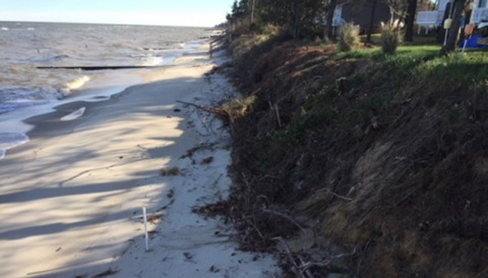
Ms. Melisi’s waterfront home in Heathsville, Virginia backs to the Potomac River on the Virginia Northern Neck, not far from the place where the Potomac River empties into the Chesapeake Bay. The case comes before the Commission on an appeal of a decision taken by the Northumberland County Wetlands Board. Per Va. Code §28.2-1311 appeals of local wetland board decisions are heard at the Commission.
Formerly Ms. Melisi’s home was protected by a beach that was 150 feet wide, plus a sand dune. Beach erosion from a storm in September 2018 narrowed the beach to 50 feet and eliminated the sand dune. As shown in the photo, her back yard no longer slopes down to the river; instead, a steep 7 foot vertical drop-off separates the edge of her yard from the recently narrowed beach.
VMRC
Ms. Melisi proposes to install 125 feet of linear rip-rap revetment. The Northumberland County Wetlands Board granted the permit. The Home Owners Association appealed the Wetlands Board decision, claiming that repairing and maintaining the offshore groin field is a better way to provide for the long term stability of the beach, as opposed to hardening the shoreline with rip-rap.
Frequently there is discussion as to whether a “living shoreline” might be the preferable solution. Adopting the strategy recommended by the Home Owners Association (i.e. repairing and maintaining the offshore groin field) would maintain a “living shoreline” at the Melisi property. Riprap is a “hardened shoreline”. As explained by the National Oceanic and Atmospheric Administration (https://www.fisheries.noaa.gov/insight/understanding-living-shorelines) living shorelines benefit the environment -- which includes people – by purifying water, buffering floods, reducing erosion, storing carbon, and attracting wildlife to habitat. During major storms, a living, natural shoreline usually performs better than a hardened shoreline although the shore erosion at the Melisi property caused by the September 2018 storm suggests that a fresh look is needed as to the design and/or maintenance of the offshore groins. A “hardened shoreline” is typically cheaper than a “living shoreline”. However, there was no discussion at the Commission as to how or whether the Northumberland County Wetlands Board weighed these factors in its decision to grant the wetlands permit.
The VMRC staff recommended that the appeal be denied. The Commission unanimously approved the staff recommendation on an 8-0 vote (Associate Commissioner John Zydron was absent).
Derrick Carpinelli (JPA #18-1630)
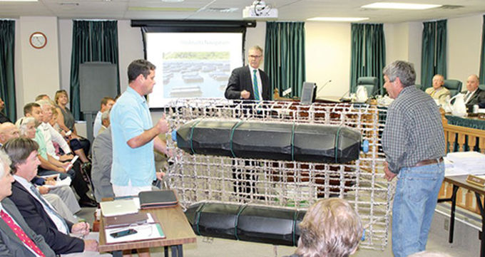
Mr. Carpinelli purchased the former Kelly’s Restaurant on the intra-coastal waterway, located at the southern foot of the drawbridge on Battlefield Boulevard, in Chesapeake. He proposes to backfill 201 feet of the shoreline, stabilizing a 103 foot segment with bulkhead and the other 98 feet with “flexamat”. He also proposes to build a pier. The project requires a wetlands permit from the VMRC pursuant to Va. Code §§28.2-1300 to -1320 (because City of Chesapeake has opted to no longer administer the Virginia Tidal Wetlands Act) and a subaqueous permit pursuant to Va. Code §28.2-1205.
As explained on the Flexamat website, “Flexamat is a vegetated concrete block mat utilized for stabilizing slopes, channels, low water crossings, inlet/outlet protection, and shorelines. It consists of [a series of small] concrete blocks locked together and embedded into a high strength geogrid. There is 1.5” spacing between the blocks that gives the mat flexibility and allows for optional vegetation growth.” As such, this product may be an attractive alternative for preventing bank erosion and maintaining a living shoreline, the benefits of the living shoreline having been described in the Melisi case (immediately preceding this one).
The VMRC staff recommended approval. The Commission unanimously approved the staff recommendation on an 8-0 vote (Associate Commissioner John Zydron was absent).
Elizabeth Place Building Company (JPA #18-0475)
Elizabeth Place Building Company is a developer that is building a 12-home community on the Western Branch of the Elizabeth River. The address is 1815 Dock Landing Road, in the City of Chesapeake. The developer proposes to build a community pier with 11 slips.
The project requires a wetlands permit from the VMRC pursuant to Va. Code §§28.2-1300 to -1320 (because City of Chesapeake has opted to no longer administer the Virginia Tidal Wetlands Act) and a subaqueous permit pursuant to Va. Code §28.2-1205.
The VMRC staff recommended approval. The Commission unanimously approved the staff recommendation on an 8-0 vote (Associate Commissioner John Zydron was absent).
Mark E. Williams and Gwen Williams Davis (JPA #18-0357)
The applicants seek an “After the Fact” permit for a 1,098 square foot boathouse and a 65 foot pier at a waterfront property (owned by others) on Virginia’s Middle Peninsula near Deltaville. The property is on the Piankatank River (address 1189 Horse Point Road, Middlesex County, Virginia).
Many years past, a certain Mr. Conger owned and operated a commercial establishment known as The Horse Point Inn at the property. One Captain Billy Williams worked for Conger. Because Captain Williams wanted to have a pier of his own, but his property was not riparian, Conger granted an easement to Williams that permitted Williams access across Conger’s land and granted riparian property rights sufficient to allow Williams to build his pier in Conger’s riparian area. (For additional information on riparian areas under Virginia law, refer to a companion article on this blog.) It appears that Williams built his pier in approximately 1967. The boathouse was built in approximately 1973.
In 1962 the VMRC gained its authority to regulate encroachments on state-owned bottom. Piers and boathouses are a trespass on state-owned bottom unless a permit is issued under Va. Code §28.2-1205. The pier and the boathouse were built subsequent to 1962 without benefit of any such permit. Fast-forward now to the present day. Mr. Williams and Ms. Davis are the successors in interest to Captain Billy Williams’ easement. Conger has long since sold his property Edward Doyle. Doyle made complaint to the VMRC regarding the pier and boathouse owned by Williams and Davis. This prompted Williams and Davis to apply to the VMRC for an “After the Fact” permit.
The VMRC staff recommended grant of an “After the Fact” permit for the pier but not for the boathouse. Instead, as to the boathouse, the staff recommended removal of the structure.
Associate Commissioners Tankard and Lusk suggested that the “After the Fact” permit should be granted for the entire structure because the pier and boathouse were in place when Doyle purchased the property from Conger. Associate Commissioner Everett argued for adoption of the staff recommendation because she is wary of rulings that may create an incentive that may encourage people to ignore the permit requirement when building piers or boathouses. Associate Commissioner Ballard and Commissioner Bowman believed that an “After the Fact” permit would not appropriate if the applicant had built the structures. However, since the structures were built greater than 40 years ago, and by other persons, they saw no good reason to require removal of the pier and the boathouse at this late date.
Associate Commissioner Tankard moved for grant of an “After the Fact” permit and a $1,000 civil penalty. Associate Commissioner Lusk provided a second for the motion, which carried on a 7-1 vote (Associate Commissioner France voted against; Associate Commissioner Zydron was absent).
Stay tuned because the attorney representing Doyle filed a notice of appeal on February 26, 2019. Va. Code §28.2-219 allows an aggrieved person to obtain court review of a VMRC decision in an appropriate Circuit Court. Va. Code §28.2-220 allows a further appeal to the Virginia Court of Appeals.
National Aeronautics and Space Administration (JPA 18-1590)
This is a $24,400,000.00 project to combat shore erosion at 20,000 feet of Atlantic Ocean shoreline at the Wallops Flight Facility, located in the northeastern part of Accomack County. The shore is eroding at 14 to 17 feet per year. If left unchecked, the ocean would threaten launch pads and other infrastructure used by NASA, the U.S. Navy, and the Virginia Commercial Spaceflight Facility Authority’s Mid-Atlantic Regional Spaceport.
NASA proposes to install two sets of three 150-foot long stone offshore breakwaters. NASA further proposes to dredge 1.3 million cubic yards of sand from the location where it believes the sand was deposited as a result of the aforementioned erosion. In other words, NASA proposes to recover the sand that was lost and bring it back.
The project required a permit under the Coastal Primary Sand Dune and Beaches Act (Va. Code §§28.2-1400 to -1420) (“The Dunes Act”). Localities may, if they wish, administer The Dunes Act. Accomack County, however, has not adopted the ordinance that would allow the County to administer The Dunes Act for itself. The VMRC, therefore, administers the act in Accomack County. As explained in another article on this blog, our experience in working with The Dunes Act includes designing an amendment to The Dunes Act that was enacted into law during the 2017 session of The General Assembly.
The project also requires a subaqueous permit pursuant to Va. Code §28.2-1205.
The lone protestor was The Nature Conservancy; it objected to the dredging.
The VMRC staff recommended approval.
Associate Commissioner Everett asked the Commission to receive the views of the Virginia Institute of Marine Science (VIMS). VIMS was chartered in 1940 and, as noted on the VIMS website, it is among the largest marine research and education centers in the United States. It conducts research in coastal ocean and estuarine science and provides advisory service to policy makers, industry and the public. Subject matter experts from VIMS attend all of the VMRC Commission meetings so that they can provide expertise when needed, with Associate Commissioner Everett’s inquiry being one example. Lyle Varnell, the Associate Director for Advisory Services at VIMS, took the podium to explain that injecting sand into the coastal system under the NASA proposal could be disruptive because of the location where the donor sand will be extracted. Scott Hardaway, a Marine Scientist Supervisor at VIMS spoke next. He is the VIMS expert on sand, breakwaters and revetments. Mr. Hardaway told the Commission that offshore structures are “the answer” but the two sets proposed by NASA are too few. Hardaway explained that NASA’s own analysis indicated that many more breakwaters are needed to stabilize the shoreline but NASA was influenced by cost when it proposed only the two sets.
Associate Commissioner Tankard offered that NASA seemed to be taking a “band aid” approach to the problem, opting for a short term solution to a long term problem. He likened it to the situation where a person puts a cheap roof on an expensive home.
Commissioner Bowman, and Associate Commissioners Ballard, Everett and Tankard all expressed the concern that NASA puts sand on the beach and it disappears, after which NASA adds sand again . . . which disappears. They, like Mr. Hardaway, recognized that NASA will only find a viable long term solution if it spends more money. In the view of the Commissioner and the just-mentioned Associate Commissioners, however, they felt that the solution was to dredge the sand from an offshore location.
The NASA representative at the hearing estimated that dredging offshore would add $10M to the cost of the project.
Associate Commissioner Ballard suggested that the additional $10M, if it were available, might be better spent on building more offshore breakwaters.
Associate Commissioner Ballard moved to accept the staff recommendation. Associate Commissioner Minor seconded the motion. The Commission unanimously approved the staff recommendation on an 8-0 vote (Associate Commissioner John Zydron was absent).
Audio of the meeting is available at http://mrc.virginia.gov/calendar.shtm.
About The Author