A New Approach to Water for Hampton Roads Cities
Reprinted from the April 2017 edition of Virginia Lawyer magazine, pages 26 to 31
Integrated Planning Approach to Municipal Wastewater
Never before has an “integrated” planning approach to municipal wastewater (i.e., sewage ) and storm water management been used for a region spanning multiple cities. A plan developed in Hampton Roads would be the first. If approved by the US Environmental Protection Agency (EPA) and the Virginia Department of Environmental Quality (DEQ), this plan5 delivers an estimated $2 billion reduction in environmental compliance costs to the cities in the Hampton Roads region while meeting or exceeding the region’s Chesapeake Bay clean-up obligations. The plan also counteracts land subsidence, which furthers efforts to equip Hampton Roads with resilience to sea level rise, restores the badly depleted volume of ground water in the Potomac aquifer, and reduces or eliminates saltwater contamination of that ground water.
Features of the “SWIFT” Plan
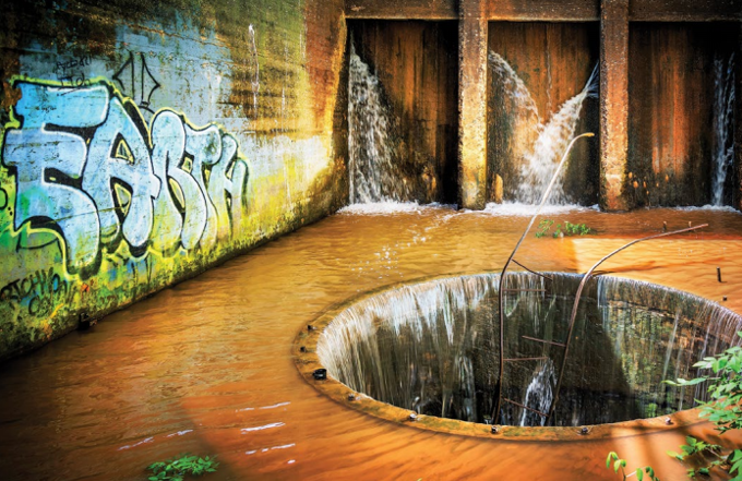
The Hampton Roads Sanitation District (HRSD) operates nine major sewage treatment plants in Hampton Roads with each plant obligated to comply with discharge limits imposed in their Virginia Pollution Discharge Elimination System permits. HRSD developed the Sustainable Water Initiative For Tomorrow (SWIFT) as a way to deliver multiple regional benefits, including responding to the EPA’s demand that HRSD and eleven cities in the Hampton Roads Region reduce the pollution they are releasing into the Chesapeake Bay.6 SWIFT creates annual savings for the region because HRSD can deliver pollution reduction at a price per pound far lower than the cost the cities must pay to deliver an equivalent quantity of pollution reduction in their Municipal Separate Storm Sewer System (MS4) permits. Nutrient trading, accomplished through use of the Chesapeake Bay Watershed Nutrient Credit Exchange Program7 (enacted by the General Assembly in 2005), is the lynchpin that allows the HRSD to spread the cost savings among the eleven participating cities. As the EPA recognizes:
Water quality trading is an approach that offers greater efficiency in achieving water quality goals on a watershed basis. It allows one source to meet its regulatory obligations by using pollutant reductions created by another source that has lower pollution control costs. Trading capitalizes on economies of scale and the control cost differentials among and between sources. (EPA, Office of Water Quality Trading Policy, at 1 (Jan. 13, 2003)).
HRSD proposes to implement SWIFT at seven of its sewage treatment plants by purifying the incoming wastewater to drinking water standards. Next, SWIFT injects8 the effluent into the Potomac Aquifer (the primary source of ground water for eastern Virginia) instead of discharging it into the James, York, and Elizabeth Rivers, thus generating millions of pounds of pollution credits annually. The cities in the region could draw upon this massive quantity of credits, valued at $2 billion, via the Nutrient Credit Exchange Program for use in eliminating inefficient requirements that would otherwise be imposed on them in their MS4 permits. SWIFT makes sure the region does its part to clean up the Chesapeake Bay while enabling environmental compliance dollars to migrate to technologies that deliver the greatest bang for the buck. SWIFT also counteracts ground water scarcity and land subsidence, two further issues of major concern in Hampton Roads.
Restoration of the Chesapeake Bay
The Chesapeake Bay is the largest estuary in the United States, and is one the largest and most biologically productive estuaries in the world. Yet, the bay absorbs pollutants from multiple sources:
- chemicals put into the air from car/airplane/ locomotive exhaust and industrial smokestacks;
- chemicals and sediment carried by storm water flowing off of lands modified by agricultural and urban development;
- chemicals that flow out of pipes carrying the contaminated wastewater from industrial operations;
- chemicals and bacteria from pipes carrying the effluent of sewage treatment plants; and
- chemicals and bacteria from ground water that is contaminated by septic systems.
One of the major negative impacts from these pollutants (among many) is low-oxygen “dead zones” that pop up during summer at various places in the bay and which are caused by nitrogen and phosphorous pollution delivered by sources mentioned above. The aggregate size of dead zones in the bay for the 2016 summer season was estimated at 1.58 cubic miles (or 2.3 million Olympic-size swimming pools).
The combination of dead zones, loss of grasses on the floor of the bay, overfishing, and introduction of disease-carrying organisms (to name a few) have devastated the fish, crab, and oyster fisheries. The oyster fishery provides an instructive example. There, “the decline in oysters has meant a loss of more than $4 billion [between 1980 and 2010] for the economies of Maryland and Virginia.”10 These cost figures are consistent with conclusions reached by the EPA in its report on the cost of nutrient pollution that was issued in 2015:
Excessive nutrient loading to waterbodies can lead to over-enrichment and algal blooms, resulting in a myriad of adverse economic effects in sectors that include commercial fisheries, real estate, and tourism and recreation, and an increase in health care and drinking water treatment costs. Additionally, mitigation measures that local governments use to reduce the effects in the water (such as algal blooms) can cost millions of dollars for a single year of treatment. (EPA, A Compilation of Cost Data Associated with the Impacts and Control of Nutrient Pollution at III-1 (May 2015)).
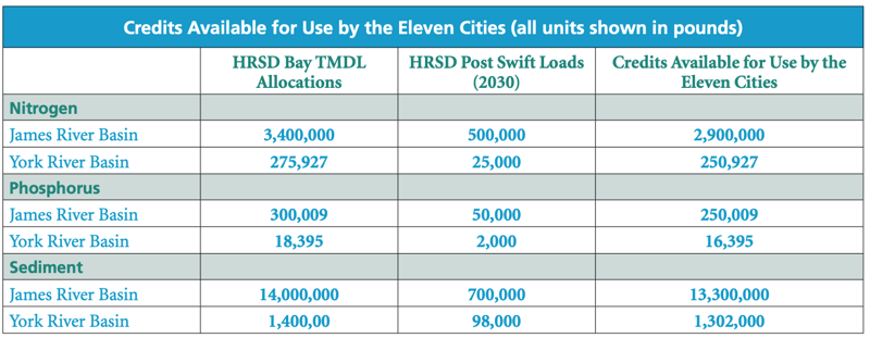
Waters that drain into the bay emanate from six states (Virginia being one) plus the District of Columbia, giving rise to the classic “Tragedy of the Commons.” Action by the federal government is the technique the Clean Water Act selected to overcome the Tragedy of the Commons paradigm. On December 29, 2010, the EPA established the Chesapeake Bay Total Maximum Daily Load (Bay TMDL). The bay TMDL establishes numerical limits on pollutant loads (measured in pounds) for nitrogen (including nitrogen deposited by air into the bay), phosphorous, and sediment that can enter the tidal portion of the Chesapeake Bay watershed. The SWIFT program responds to the bay TMDL in the two geographic areas of the Chesapeake Bay known as the James River Basin and the York River Basin. The chart below shows the extent to which SWIFT can meet the needs of the eleven cities in the region:
Restoration of Ground Water
Although the HRSD’s primary motivation for the SWIFT project is reducing nutrient and sediment discharge into the bay, there are a number of other significant water issues in the Hampton Roads region that require a long-term comprehensive solution. These problems include: depletion of ground water in the Potomac Aquifer; land subsidence both natural and due to aquifer depletion; sea level rise caused by climate change and exacerbated by land subsidence; and, threat of saltwater intrusion into and contamination of the aquifer. Depletion of the Potomac Aquifer is similar to the “Tragedy of the Commons” paradigm that occurs with historical pollution flowing into the bay.
The Potomac Aquifer underlies a vast region from North Carolina to New York. Thousands of industries and half a million households take water from the aquifer. (The estimate for Hampton Roads is approximately hundreds of industries and 25,000 households.) Today this equates to permitted withdrawals of around 147 million gallons per day (MGD), with actual withdrawals totaling 115 MGD. Another 40 MGD of withdrawals occur from an estimated 200,000 unpermitted “domestic” wells located throughout eastern Virginia. When this level of ground water is pumped from an aquifer system, water levels and water pressure decrease. The natural “mound” of subsurface fresh water and related pressure keeps adjacent saltwater from contaminating the freshwater in the aquifer. When the pressure and size of this mound decrease, the risks of saltwater contamination into the aquifer increase. Pumping ground water out of the aquifer also affects the level of the water table. Over the past 100 years the water table has dropped at some locations from 31 feet above sea level to 200 feet below.
In addition, the Potomac Aquifer system is made up of many horizontal layers of clay and sand separated by ground water. As ground water is eliminated from the aquifer these horizontal layers of clay and sand move closer to one another, which causes the surface land to subside. This man-made subsidence is in addition to the naturally occurring subsidence due to long-term geological settlement conditions resulting from the existence of glaciers thousands of years ago. Land subsidence magnifies and worsens the negative effect of sea level rise due to climate change. Indeed, land subsidence in Hampton Roads “causes more than half the relative sea-level rise” with “aquifer-system compaction [explaining] the majority of observed land subsidence.” Thus, depleting the aquifer increases the risk and significance of flooding in the region. The flood risk in the Hampton Roads region is second only to New Orleans in the United States.
Moody’s Investor Service, a leading provider of credit ratings, research, and risk analysis, is performing a “Coastal Virginia Credit Focus Review” to assess how sea level rise/ recurrent flooding would affect the Moody’s rating for bonds issued by Virginia Beach. In response to the Moody questionnaire the city confirmed that it spent $43.8 million for flood-control projects over the last five years, and would spend an additional $135 million over the next ten years.
In addition, an Intergovernmental Planning Pilot Project (IPP) was formed, with broad federal, state, and local government participation, for the purpose of coordinating “sea level rise preparedness and resilience planning” for Hampton Roads. Following two years of work, the IPP issued a resolution dated June 27, 2016, executed by all of its members (save one), calling for the formation of an entity to facilitate and plan actions that will make Hampton Roads resilient to the impacts of sea level rise.
When fully built out by the year 2030, SWIFT will replenish the aquifer by injecting 120 MGD back into the Potomac Aquifer. The source for the ground water replenishment will be the purified wastewater discharged from seven of HRSD’s sewage treatment plants. The SWIFT advanced treatment process purifies the water to levels equal to or better than the current aquifer water and to levels that match the chemistry of the ground water in the aquifer (which eliminates the possibility for new problems). SWIFT, if approved, should reverse the degree of land subsidence and substantially replenish the aquifer.
Conclusion
SWIFT is an unprecedented integrated planning win-win. The HRSD’s trailblazing effort to integrate municipal wastewater and storm water management compliance for the Hampton Roads region will, if approved, capitalize on economies of scale and control cost differentials that will clean up the bay while delivering an estimated $2 billion reduction in environmental compliance costs to the cities in the Hampton Roads region. SWIFT will, in addition, counteract land subsidence, which furthers the efforts to equip Hampton Roads with resilience to sea level rise, restore the badly depleted volume of groundwater stored in the Potomac Aquifer, and reduce or eliminate saltwater contamination of that groundwater.
About The Author